Friday, June 19, 2015

Earthquake in Vancouver

1) According to a Global News, news report, we knew a major earthquake would be hitting Vancouver as seismologists are aware that a large earthquake happens approximately between 200 to 800 years apart. The last large earthquake occurred in 1700 meaning, statistically BC was expecting one. Other evidence predicting that the major earthquake would happen is that the second largest tectonically active fault system in North America, reaches 1200 km from northern California to Vancouver Island.We know major earthquakes would occur in the area along the Cascadia subduction zone with the epicentre being near Haida Gwaii in the Juan de Fuca straight based on the evidence of past earthquakes. Vancouver is positioned in a seismically active region where large and destructive earthquakes have happened in the past.  A major earthquake could occur at any time. The Metro Vancouver region lies at the forefront of the North American plate and on the western edge of the plate, the Juan de Fuca plate is subducting beneath and is slowing deforming the continent.

2) The geological setting makes this heavily populated region susceptible to frequent seismic activity. This area also has increased risk of disastrous megathrust earthquakes. The Metro Vancouver region is surrounded by the Coast Mountains and the Pacific Ocean which makes it vulnerable and isolated during a large earthquake.

3)
a.
Liquefaction is a process in which the durability and solidity of soil is compromised by earthquake movement. This is a hazard because when it occurs, the solidity of the soil decreases and the ability of soil deposits to support foundations for buildings and bridges are reduced. It can be responsible for a tremendous amount of damage and a hazard for many lives. Liquefaction would be a major issue in the South Delta, Richmond and Tsawassen area because they are at sea level and the ground can easily become liquefied.


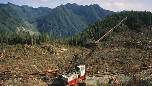
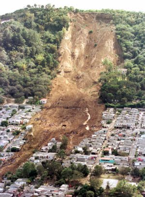
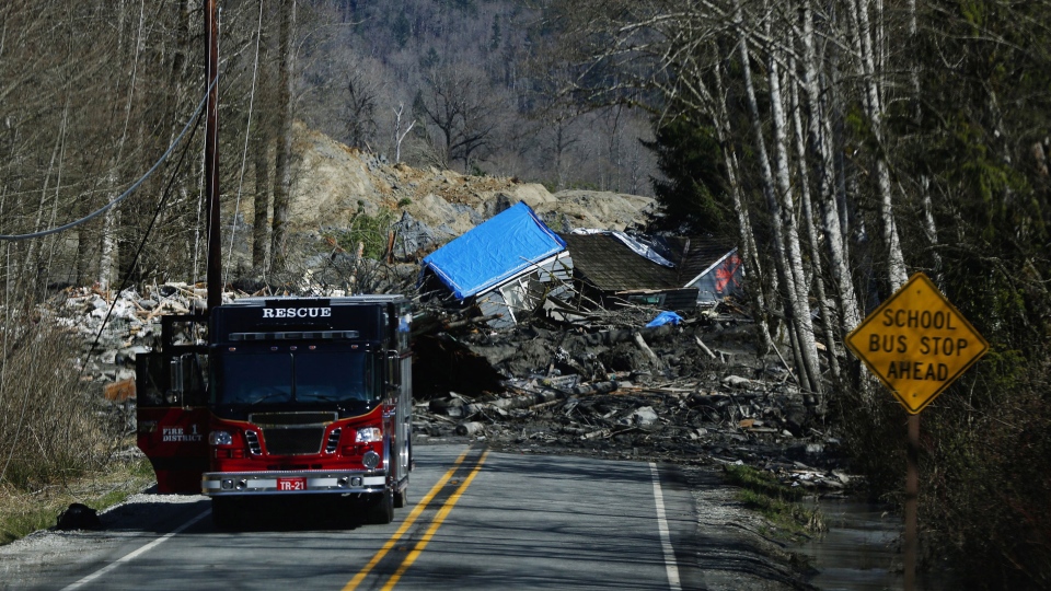
Landslides are the movement of rock, debris or earth down a slope. Sudden and rapid landslides are most dangerous because of the lack of warning and the speed at which material can travel down the slope, also the force on resulting impacts impact. Extremely slow landslides may not be a threat to people but it can cause considerable damage to property. There are many resources that could be ruined, for example water supplies, fisheries, and roads. Landslides would be a major issue in the North Vancouver and Vancouver Island and Gulf Island areas because of all the forests and hill sides and mountains with loose rocks and unstable land.


Tsunami's are giant waves that can be caused by earthquakes or volcanic eruptions under the sea. As the waves travel toward land they increases to extremely high measures as the depth of the ocean decreases. The speed of tsunami waves are dependent on ocean depth rather than distance from the source of the wave. In some cases they can result in floods reaching up to 100 feet in height. They can cause a lot of property damage, environmental damage and leaving many lives at risk. A tsunami would definitely be a major concern for Victoria and other cities along the coast of B.C. because they aren't a major land mass and can easily be swept under water and many peoples lives would be destroyed.

Flooding is a natural disaster that occurs where a dry area of land becomes submerged under large quantities of water. Floods that happen in areas where people live, the water carries along whatever can removed from the ground such as houses, bridges, cars, furniture, and even people. It can wipe away farms and trees as well. Flooding would occur along Vancouver Island and all the cities and towns along the Pacific Ocean like Vancouver and Richmond. The sea level would rise causing these areas at sea level to flood

b.
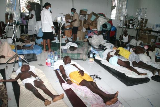
I) Social Impact : Earthquake hazards pose serious intermediate term risk to health and safety and economic viability. They demonstrate risks to industrial societies from the event, affecting everything from massive loss of life, infrastructure damage and financial instability. Earthquakes can have short term and long term impacts. Short term impacts would include injured people, destroyed homes, disruption to transportation and communication. Long term impacts would include a release of a wide spread disease and peopling having to re-house.

II) Economic Impact : Earthquakes can result in massive destruction of roads, bridges, farms, houses, automobiles and people become homeless. The government deploys fireman, police and other emergency apparatuses to help the affected. Everything comes at a heavy cost to the people and the government. It takes years for affected communities to be re-built and businesses to come back to normal.

III) Infrastructure Impacts : Earthquakes can effect availability of many services and elements of infrastructure. The large and violent movement of the ground caused by an earthquake will disrupt many services. Electric line poles are vulnerable to damage. No electricity results in no light, heat and no water. Land-line phones will not have service as the towers may be damaged. Natural gas pipelines could also be broken. Almost all stores rely on supplies being brought by trucks, so supply lines will be impacted. Local airports and train facilities can also be damaged. Bridges, buildings, and hospitals can be destroyed or damaged causing a great effect.

4)
Metro Vancouver is preparing for the impending earthquake by:
To protect our infrastructure:
-Bridge upgrades
-Dedicated Fire Protection System (DFPS)
-Stormwater management
-Mapping flood hazards
-Extreme weather response
To protect the community:
-Emergency Social Services
-Public education
-Specialized response
Coordinated planning and response:
-Earthquake Preparedness Strategy
-Regional collaboration
-Emergency communications
-Consolidated radio and dispatch
-Emergency Operations Centre

Thursday, June 18, 2015

Case Study: flooding in Brisbane

1) Flooding is caused by many different reasons, both natural and human related. It usually takes place in coastal locations. Some natural causes of flooding are hurricanes, storms and tsunamis. However the major cause of flooding in Australia is heavy rainfall. Human causes to flooding can be urbanization and mining. Another major reason for flooding can be pollution and infrastructure. There can be various reasons for flooding either naturally or due to human influence however they all can cause different levels of destruction to environments depending on the size and capacity of the flood.

2) I. Economic Impacts:
- Damage to properties
- Cost of rescue aid by Federal Government
- Price of food increases due to limited supply
-Firefighters, police officers, and other emergency apparatuses come at a heavy cost to people and the government.
- Relief and recovery costs
- Reparation to the city

II. Social Impacts:
- People killed
- Loss of homes
- Spread of disease and infections
- Physiological impacts on people (trauma, loss etc.)
 
III.Environmental Impacts:
- Destroyed plant life
- Water contamination
- Animals killed due to drowning
- Balance of ecosystem disrupted
- Damage to environment/landscape


3) The city of Brisbane is built directly on top of a floodplain, so completely preventing future flooding is impossible. However, the city council of Queensland has created a flood-smart future strategy of six strategic outcomes to protect and better prepare their city and its populants for future floods. The six strategic outcomes consist of a risk based approach to flood management, an integrated and adaptive approach, smart planning and building, an educated and resilient community, world class response and recovery and lastly well maintained and improved structural assets. By educating their city about flooding and how to flood proof their homes and community by working together it'll create a stronger bond within the community and better preparation so that when the next flood may come they will be ready, and much less loss and destruction will occur.

Land use and Agriculture In Haiti


1) Describe the land use in Haiti.
Haiti is mostly mountainous, however approximately one third of the land is arable. Once covered by forest, the country has been heavily logged for wood and fuel as well as to clear land for farming, and is now dangerously deforested. The deforestation has contributed to often deadly and sometimes devastating flooding during hurricane seasons. In 2000, 58% of Haiti was agricultured land, 28% was arable and 4.2% was forested, due to the massive earthquake that took place there is no updated information to compare except for that in 2010 the forested land in Haiti reduced to 3.7%.

2) Pros and Cons

I) Monoculture
Pros:
-Reduced plant competition for nutrients, space and solar radiation
-Control of undesirable (unprofitable) organisms
-Reduction of costs by limitation of specialized machinery required for arable operations

Cons:
-Lack of biodiversity
-Single threat can destroy all the crops
-Needs a complex irrigation system
-Diseases/pests spread more effectively in monoculture.


II) Polyculture
Pros:
-Needs less complex irrigation system
-Reduces number of pests, weeds, and disease outbreaks because of increased variety of plants
-More stable type of agriculture
-Consistent income for farmers since they don't need to depend on one type of production
Cons:
-Higher investment in equipment
-Laborious task for farmers
-Farmers need to have knowledge of all their plants since there's such a large diversity
-Difficult for farmers to control and supervise because of the different types of crops


III) Slash and Burn
Pros:
-Removes debris
-Less equipment used for farmers, cheaper
-Returns nutrients to soil
-Crops are recycled on site so decomposition occurs on fields

Cons:
-Fire hazard
-Hazardous to animals
-Hazardous for humans, smoke can be a negative impact on health
-Soil left bare for a long time will create erosion


3) With 66% of the laboring population making its living solely from the soil, farming is the mainstay of the Haitian economy. Only about one-third of the country's land is considered suitable for cultivation because of the rugged and mountainous terrain. Some of Haitis important staple crops are beans, maize and rice however it's most important staple item is coffee beans which in 1999 produced a record amount of 28,000 tonnes. Sugar cane is the second major cash crop but production has been declining yet in 1976, Haiti became a net importer of sugar. Haiti employs an unusual form of farming called arboriculture. Combinations of fruit trees and various roots, particularly the manioc plant, the traditional Haitian bread staple, replace the grain culture of the usual subsistence-economy farming. Crops are cultivated with simple hand tools; the plow or animal power is only rarely employed, except on sugarcane plantations. Coffee is grown on humid mountain slopes, cotton on the semiarid plateaus and sea-level plains, and bananas as well as sugar on the irrigated plains, which covered about 17,000 hectares in 1999. Rice has become a basic staple for Haitians, but local production only meets a little more than 20% of demand.

Rice Crops in Haiti


Case Study: Desertification in Botswana

1) Desertification is the process in which flourished, fertile ground undergoes environmental or human inflicted change such as drought, deforestation or inappropriate agriculture and becomes barren and desert.

2) Botswana is located just above the Tropic of Capricorn. Botswana's semi arid and drought prone environment is one of the natural contributing factors to it's desertification as well as soil erosion from wind, sheet wash and gullying. The Kalahari, isn't a true desert as one would presume, it is actually covered by a vegetation mantle that resides from woodland and close-tree Savannah in the north, to low tree and shrub Savannah in the south and west. Areas are also covered in sand dunes occasionally especially in the west and southwest, however except for an area in the North, the country suffers from lack of surface water. Rainfall varies considerably each year and is extremely unpredictable, usually falling in scattered showers. Due to high daytime temperatures, evaporation is typically very high at a daily open water evaporation rate of 7.5 mm.

3) Human causes to desertification in Botswana are overstocking and large-scale vegetation depletion. Commercial exploitation of Botswana's fragile eco-system such as highly concentrated cattle in certain areas results in overgrazing and trampled top soil, both contributing factors to desertification. Uncontrolled development of cattle posts in areas set aside for wildlife management, resulted in the emergence of land use conflicts and extensive degradation of the tree savannas. The local people of Botswana have degraded their own environment through intensive grazing by livestock and intensive use of the natural vegetation cover for fuel-wood and other veld products.

4) Some of the steps that have been taken in attempt to rehabilitate the environment and protect people of Botswana have been to make people publicly aware of the effects of their lifestyles and urging them to change or alter them, reclamation of gullies and dongas, woodlots and plantations, sand dune stabilization and newly planted nurseries. Some of the challenges that were faced by Botswanian people were limited community knowledge, limited capacity for human and infrastructure, the need to increase agricultural land at the expense of forest reserves and finally uncontrollable climate change.


Case Study: Glacial Retreat

Part A. How are the Glaciers in each area behaving?

1.  The climate and affect it has on glaciers are interwoven, Glaciers respond to change in climate in terms of glacier length, mass balance and runoff.

I) In the Himalayas due to the rising temperature, Himalayan glaciers are melting faster than in other areas of the world. It has been recorded that there is less snowfall during the winter and an increase in temperature of 1.6 degrees Celsius in the summer. Less snow in the winter and warmer temperatures in the summer will cause a higher equilibrium line and in result of that, a negative mass balance causing the glacier to retreat. According to satellite images study and field investigations at the Chhota Shigri glacier done in 1988 and 2003 suggest a retreat of 800 meters from 1988- 2003.

Himalayan Glacier
II) In Glacial National Park glacier recession is extremely potent, and many glaciers have dissipated completely. The retreat of these small alpine glaciers reflects changes in recent climate as glaciers respond to altered temperature and precipitation. It has been estimated that there were approximately 150 glaciers present in 1850, and most glaciers were still present in 1910 when the park was established but by 2010 only 25 glaciers larger than 25 acres were left remaining. Tree-ring based climate records reveal Pacific Decadal Oscillation effects that have resulted in 20-30 year time frames of hot, dry summers coupled with decreased winter snow-pack which is whats influenced GNP's regional climate so negatively.


III) The Antarctic Peninsula is a rugged mountain chain typically over 2,000 m high, differing from most of Antarctica by having a summer melting season. Records show mean annual temperatures on the Antarctic Peninsula have increased rapidly over the past 50 years. On the west coast, warming has been much slower in summer and spring than in winter or autumn, but has been sufficient to raise the number of positive degree days by 74% and the increase in melt has caused dramatic impacts on the Antarctic Peninsula glacial survival. The rate of warming on the Antarctic Peninsula is among the highest seen anywhere on Earth in recent times, and is a dramatic reminder of how subtle climate-dynamic processes can drive regional climate change, and the complexity of its impacts in an environment where human influence is at a minimum.

Antarctic Glacier retreat

2. Discuss social, economic and environmental impacts of Glacial Retreat.

Economic impacts:
- Loss of money from lack of tourists
- Expense to rebuild homes and towns from possible destruction
- Relief and recovery costs from possible destruction


Social impacts:
- Livelihoods at stake in case of natural disaster
- Rising sea levels cause people to relocate
- Farms and crops can be destroyed


Environmental impacts:
- Sea level increase of 6 to 8 inches due to melting glaciers in the past 100 years
- Wildlife that live near glaciers are losing their habitats and becoming extinct
- Causes natural disasters
- Can alter flow of downstream rivers

Part B.

Glacial retreat has a horrific impact on the tourist industry. People spend thousands of dollars to go on cruises and trips to see the glaciers and if they are quickly disappearing tourist industries are at a catastrophic financial loss. Alaska, Banff, Swiss Alps, Glacier national park are all huge tourist attractions and thousands of tourists visit Alaska's glaciers every single year. As they shrink due to global warming and other reasons, many of them are becoming less available to tourists. The Swiss Alps have a massive tourist industry for mountain biking and hiking however as the glaciers are melting so rapidly rock falls are increasing creating dangerous risks to tourists resulting in a steeply declining tourist visit rate. Banff is one of the worlds most visited national parks however with the Rockies glaciers loss of 25% of their mass in just the 20th century, the only industry in Banff being the tourist industry is at a torrential downfall.

Part C.

Glacial retreat has no immediate affect on Haiti therefore I will choose to discuss general impacts of glacial retreat. The general impacts of glacial retreat have occurred worldwide affecting the survival of plants and animals, the availability of fresh water for irrigation and domestic use and mountain recreation. These factors all depend on glacier-melt, and in the long run and to some extent so do sea levels. In areas that are heavily dependent on water runoff from glaciers that melt during the hotter summer months, if the current rate of glacial retreat continues at the same pace, the glacial ice will eventually be entirely depleted and substantially reduce or eliminate runoff. A reduction in runoff will affect the ability to irrigate crops and will reduce summer stream flows necessary to keep dams and reservoirs replenished.


Sunday, June 14, 2015

Water Use in Agriculture

Drip Irrigation: An irrigation method that saves water and fertilizer by allowing water to drip slowly to the roots of plants, either onto the soil surface or directly onto the root zone, through a network of valves, pipes, tubing, and emitters

PROS- Efficient use of water, applied evenly, balanced distribution of nutrients and salts which enhances healthy growth of plants and conserves water which is environmentally friendly.

CONS- Expensive investment, requires frequent maintenance(cleaning through filtration) and constant monitoring
Drip Irrigation Diagram


SprinklerWater is distributed through a system of pipes usually by pumping. It is then sprayed into the air through sprinklers so that it breaks up into small water drops which fall to the ground.(Similar to natural rainfall)

PROS- Can work at low pressures, saving energy. Can achieve high uniformity of application, thus water efficient if combined with scheduling system. Easy to apply frequent light irrigation

CONS- Higher capital costs than rainguns. Need to take care in windy conditions that uniformity is not distorted
Sprinkler Diagram

Surface IrrigationIrrigation where an entire field is flooded, or the water is directed into furrows or borders

PROS- Minimal capital investment or energy costs, less affected by climatic and water quality factors. Easy to see the effectiveness of the system.

CONS- Tend to be less efficient than other systems, labour intensive and sometimes difficult to engineer. Can be higher disease pressure (especially flood)

Surface Irrigation
In consideration of the pros and cons of each irrigation system I think the best system to be used in agriculture is the sprinkler system. Reasons being, it is able to work at low pressures and save energy. In a scheduled system, it can achieve high uniformity of application. It is also the most efficient way to water land quickly and evenly. The only concern to the sprinkler system is that it can be somewhat expensive however the quality and efficiency of the sprinkler outweighs the cons.

Deforestation in Haiti

        Deforestation in Haiti is a grave environmental problem. In 1923, over 60% of Haiti's land was forested and by 2006, less than 2% of the land in Haiti was forested. After Hurricane Hazel wiped out a mass amount of trees in 1954, the rate of deforestation accelerated severely. Logging operations were also increased during this time to keep up with Port au Princes high demand for charcoal. Because of environmentally unsound agricultural practices, rapid population growth, and increased competition over land, the rate of deforestation was dangerously increasing. Techniques that could make forestry more productive for fuel, like coppicing and pollarding, were not used at all. The most dire effect of deforestation in Haiti is soil erosion. An estimated 15,000 acres of topsoil are washed away each year, with erosion also damaging other important infrastructure such as dams, irrigation systems, roads, and coastal marine ecosystems. Soil erosion also lowers the productivity of the land, worsens droughts, and eventually leads to desertification, all of which increase the pressure on the remaining land and trees, as well as quality of life for Haitians and overall trading that occurs in the country. USAID's Agroforestry Outreach Program, was the country's major reforestation program in the 1980s which set forth the efforts toward reviving Haiti's forests as peasants planted 25 million trees however seven trees were cut for each new tree planted. Later efforts to save Haiti's trees focused on intensifying reforestation programs, reducing waste in charcoal production, introducing more wood-efficient stoves, and importing wood under USAID's Food for Peace program. Haitians still depend on wood and charcoal as their primary fuel source therefore energy alternatives are needed to save the forests. The 15-year Environment Action Plan authorized in 1999 suggested to stop deforestation by developing alternative fuel sources however political instability and lack of funding have limited the productivity and effectiveness of this reform effort.

Deforestation in Haiti
       Based on the information given in the "Deforestation in Canada" folder I have come to the belief that deforestation is treacherously worse in Haiti than in Canada. I hold this understanding based on the evidence that "Canada’s deforestation rate accounts for only 0.4% of global deforestation" which is quite minimal. In addition "Deforestation affected less than 0.02% of Canada’s forests in 2005" compared to Haiti in which by 2006 only 2% of its land was forested. These are extreme differences which expresses viable and obvious proof that Haiti's level of deforestation is immensely more severe than Canada's.
Deforestation in Canada

Energy Assignment Part 3

From the three energy types I researched in part one I rank solar power as having the most potential to be implemented in Haiti, Wind as second and Tidal as last. Solar power has the most potential to be implemented in Haiti as it is already in the process of being tested for such use. Haiti receives excessive amounts of sunlight all year long and clear skies on average of 71% a day and would be an excellent candidate for this sustainable and smart system. Wind energy is second because it is also in the experimental stages of being the upcoming sustainable and renewable energy source for the Caribbean islands. Wind power is simple and efficient as individuals do not need to own wind turbines to get power, it is simply installed in general empty areas and can be used for vast locations. Tidal energy would be last due to the fact that the installation of tidal systems are very expensive and because torrential storms and choppy waves are common in Haiti, repairs for equipment may end up being too frequent and too expensive for upkeep.

Solar panels being installed for newly built hospital

Water Use in Haiti

1) My reaction to the documentary we watched in class was shock and disbelief. I've heard before from other documentaries that big companies in the food industry have a lot of control and do terrible manipulative things to get ahead in the system but I never expected it from beverage companies, especially Nestle! It's sad to me that water is becoming vanquished in some countries and that it's happening due to greed of a company and that so many people in Canada are unaware. We are so fortunate that in Canada clean drinking water is literally accessible just by a tap in our homes yet we still go out and buy it from these companies that are taking it from less well off countries where villagers are dying from lack of clean water, it's really disturbing and heartbreaking on a whole new level. The documentary gave me a whole new insight and appreciation for the ease of survival that we have in Canada and I do not think it's right what these corporations are doing whatsoever and I agree 100% that the villagers should protest and fight for clean water as well as their rights to survival.


2) Haiti has the lowest rates of accessibility to improved water and sanitation infrastructure in the western hemisphere. After the earthquake in 2010, Haiti's water supply and sanitation was left in an even more detrimental state than prior to. Only 69% of Haiti's population has access to an improved water source and 17% had access to improved sanitation facilities in 2010. This raises a huge issue as due to the highly dense population in such a small Island in addition to the Cholera outbreak that occurred due to bacterium contaminated drinking water after the earthquake, over 8927 Haitians deceased due to this pandemic and the lack of sanitary drinking water. Unsanitary drinking water and Cholera is still an ongoing issue in which they can tackle with donated funds for water treatments and vaccinations for sick patients.

Treatment of Cholera victims

Wednesday, June 10, 2015

Case Study: Mass Wasting in China

On August 8th 2010, an absolutely treacherous landslide occurred in Zhouqu China killing 1117 people plus 627 missing, 300 buildings buried under mud, 66% of the county left without power and 1000 homes damaged or destroyed in addition to 3000 completely flooded. The landslide was reportedly caused by immensely heavy rainfall thought to be caused by 'Zhou Pinggen' to the contributing factor of "half a century of unrestrained logging" resulting in declined forests, setting the ecosystem out of sync. The landslide was further expanded as the blasting of debris that was damming the Bailong River creating an unstable lake that overflowed and sent a tremendous wave of water over the entire town of Zhouqu, shortly after the initial landslide. This natural disaster was so horrific due to reasons that citizens should have been warned and prepared for the event as it was foreseeable by experts from previous weather patterns and risks, however the highly controlling government system fell short to prepare citizens resulting in tremendously high death tolls and irreparable damages to the whole town. The landslide may have absolutely been prevented if geographic and geological concerns such as excessive logging, frequent earthquakes, poor weather and the terrain of the area were heeded attention to and understood, precautions may have been held in place and countless citizens and homes and buildings of Zhouqu may have survived.

Parts of a Landslide.
Landslides are commonly caused by heavy, torrential rainfalls on steep slopes that can cause large masses of soil to slip and wipe out people and buildings. Landslides are definitely possible in Haiti as there are abundant mountainous terrain that during rain and storm seasons can be compromised to mud and land slides. Human causes of landslides are excavation, mining, pollution, water leakage, deforestation, loading and many more. Landslide prevention methods persist as improving surface and subsurface drainage, removing soil and rock at the head of the landslide decreasing driving pressure, buttressing the toe of the landslide and constructing piles and retaining walls using metal beams driven into the dirt to properly hold piles in place to with stand sliding mud and earth.


Energy Assignment Part 2

After the massive earthquake that took place in 2010 little is known about Haiti's electricity generation and transmission facilities. However prior to the disaster Haiti relied on imported petroleum and unstable electricity generation to provide electricity, 12.5% of the nine million people of Haiti's population had access to electricity before the earthquake. The national electricity company of Haiti was created in 1971 to control the generation and distribution of electricity and in 2006 the total installed capacity was 270 MW, of which 70% was diesel oil-fired thermal and 30% hydroelectric. The hydro-electric plant's capacity relies upon the seasons, which is much lower in the dry season. The thermo-electric plan'ts appear to be run on imported petroleum, this system of electricity generation is not well connected to the country's provincial areas at the moment. Oil, coal, nuclear power and natural gas are not produced in Haiti as they import 14 thousand barrels of oil per day in 2008. Wood is the principal energy source for the majority of Haitians, accounting for 75% of the nation's energy consumption. The reliance on wood for a fuel source has resulted in severe deforestation of Haiti; with one source estimating 6,000 hectares of soil lost each year to erosion. Little is known about the current system of electrical generation in Haiti, but given that the electrical system relying on unreliable imported fossil fuels was not functioning well before the earthquake it is likely that a completely new system will arise soon for Haiti, a possible candidate being solar power as they obtain an abundant source of solar energy.

Tuesday, June 9, 2015

Energy Assignment Part 1

Solar

pros:
- Reduces dependence on fossil fuels
- Lessens the need of electricity from utility companies and also results in extra savings
- Clean energy source; solar panels do not release contamination into the environment
Renewable and sustainable energy source, we cannot run out of solar energy unlike energy from fossil fuels which is limited
- Low maintenance as modern solar panels don't involve any moving parts and last for about 20-25 years

cons:
- Price to install solar panels on your home are very expensive especially if more than one solar power is required
-Solar energy is only capable of producing power during the daytime, meaning for about half of the day no energy is being transmitted throughout your home
-Solar cells effectiveness; air pollution can effect the intensity of the solar rays reaching the panels, therefore lessening the amount of energy being produced
- Requires a large space for set-up, especially for businesses you may not be able to fit them on the roof of the building to produce the right amount of energy
-Expensive storage; Solar power is utilized to charge batteries for the home or business, so that during the evening hours you will still have access to power. These batteries are heavy and large. A large area is needed to store them, and they will have to be replaced occasionally, which can add to the cost.

Tidal

pros:
-Consistent power; tides move constantly throughout the day, which creates a consistent stream of electricity generation capacity.
-Pollution free; by taking advantage of only the tide, tidal power creates no greenhouse gas emissions or water pollutants.
-Low operating costs; once installed there are few ongoing operating costs or labor costs, unless there is a device breakdown.
-Renewable; no material resources are used or changed in the production of tidal power, making it a truly renewable power form.
-Minimal visual impact; tidal power devices are fully or nearly completely submerged in water, out of sight, this reduces the “damaging of water views” that has been associated with offshore wind turbines.
-Efficient; tidal power converts 80% of the kinetic energy into electricity, as opposed to fossil fuels which convert only 30% of the energy held within

cons:
-Device Breakdown; strong ocean storms and salt water corrosion can damage the devices, which could increase the cost of construction to increase durability and/or cause frequent breakdowns.
-Shifting Tides; changes in tidal movement could substantially reduce efficiency of TSGs.
-Marine Life Affected; sea life could be harmed by the blades in the open and Venturi turbines. The floor mounting of TSGs could also disrupt the habitats of different sea life and plants.
-High Initial Costs; the high cost of the different TSGs and cost of installing power lines underwater could lengthen the payback period and be cost prohibitive based on the characteristics and size of each project.
-Few Implemented; there are relatively few commercial installations as compared to other technologies, such as wind and solar farms. As such, additional difficulties implementing these TSG devices could arise.

-Reduced Sea Usage; the potentially larger footprint of TSG farms could reduce shipping and recreation areas.

Wind

pros:

-Clean source, unlike using coal or oil, creating energy from the wind doesn’t pollute the air or require any destructive chemicals
-Renewable, in the event that you live in a geological area that gets a lot of wind, it is ready and waiting and free
-Cost effective, wind turbines can give energy to numerous homes. You don’t actually have to possess a wind turbine keeping in mind the end goal to harvest the profits; you can buy your power from a service organization that offers wind energy for a specific area
-Use of modern technology, wind turbines are considered attractive and modern looking on your land
-Extra savings for land owners, land holders who rent area to wind homesteads can make a considerable amount of additional cash, and wind energy likewise makes new employments in this developing engineering field

cons:
-Wind reliability; wind doesn't generally blow reliably, and turbines usually function at about 30% capacity or so. In the event that the weather is not going to support you, you may wind up without power (or at any rate you’ll need to depend on the electric company to take care of you during those times).
-Threat to wildlife as the edges of wind turbines can actually be unsafe to natural life, especially birds and other flying creatures that may be in the area
-Noise pollution, wind turbines make a sound that can be between 50 and 60 decibels, and if you have to put it next to your home
-Expensive to set up; wind turbines and other supplies needed to make wind energy could be extremely costly in advance, and relying upon where you live, it might be hard to find someone to sell them to you and somebody who can maintain it over time.
-Safety of people, severe storms and high winds can cause damage to the blades of wind turbine. The malfunctioned blade can be a safety hazard to the people working nearby. It may fall on them causing life term physical disability or death in certain cases.

Thursday, June 4, 2015

Land Subsidence in the American Southwest

a) Causes of Land Subsidence in the American Southwest

- Land subsidence is majorly caused by the over drafting of aquifers and is steadily getting worse as ground-water pumping increases
- Pumping water, oil and gas from underground reservoirs
- Dissolution of limestone aquifers also called sinkholes
-Collapse of underground mines
- Drainage of organic soils
- Hydrocompaction, which is the initial wetting of dry soils

Land subsidence has been getting worse over the past recent years as global warming is altering the weather patterns and seasons, many States in America suffer from drought and immense water shortage and aquifers are being overused and abused and not pertaining enough time to collect more water before it compresses resulting in land subsidence.

b) Potential impacts of Land Subsidence

Issues and dangers that can be arisen from land subsidence are changes in elevation and slope of streams, canals and drains, damage to infrastructure such as railroads, bridges, storm drains, sewers etc, as well as damage to private and public buildings. Some more damages that can be caused due to this issue are failure of well casings from forces generated by compaction of fine grain materials in aquifer systems.

c) Ways to prevent further Land Subsidence

Possible solutions to preventing further and extensive Land Subsidence in various part of the US are switching to alternate methods of receiving water such as surface-water supplies, importation of water or creating wells or large water storage vats or drums. Reducing usage from aquifers to allow them time to replenish ground water levels and spreading awareness among communities of the dangers of Land Subsidence to use precautions against excess unnecessary water use.


Wednesday, June 3, 2015

Waikiki Beach Case Study

1) Causes of erosion on Waikiki Beach:
a) The Pacific's rough current wears away the smooth surface of the sand
b) The construction of sea walls
c) The loss of coastal dunes buried by man made structures
d) Storms
e) Fast moving motor crafts

2) Past and Present attempts to save the sand on Waikiki BeachIn June of 2012, the state’s Department of Land and Natural Resources completed a beach replenishment project that added 24,000 cubic yards of offshore sand across 1,730 feet of Waikiki's Beach. I believe this was a good attempt however one fourth of the sand was washed away after only one year of the $2.2 million project, therefore I think it bought more time but was not a permanent solution. There has been ten replenishment projects since 1939, meaning 300,000 cubic yards of sand has been placed on Waikiki's beach over the past seventy seven years. Replenishing the sand isn't a solution to the erosion issue it's only prolonging the survival of the beach. An upcoming project to save the beach is the creation of a nonprofit Waikiki improvement district under Bill 82, which would raise funds for restoration efforts. The bill passed first reading earlier this month and was referred to the Zoning and Planning Committee for further debate. |

3) Economic, Social and Environmental impacts on tourists and residents of the area
Economic Impacts:
-Erosion on the Waikiki shoreline is detrimental to the economy of Hawaii as the beach is a major tourist attraction as well as most of locals businesses rely on sales related to the beach environment
- Local shops and businesses lose money due to declined tourist rates
- The entire economy of the state is greatly shortened due to expenses of beach replenishment, loss of tourists and expensive injuries caused by beaches
- Lack of houses and hotels being bought and sold by the shores because of noise and disruption from machinery
- Cost of beach replenishment

Social Impacts:
- Tourist counts are reduced due to the loss of the shoreline and lost beach
- Less people on and near the beaches
- Locals have their water sport hobbies restricted due to dangers of surfing near the shore and being injured by exposed concrete
- The future of Waikiki's beach is on the line of disappearing which would mean the loss of Hawaii's most cherished beaches, effecting the country on a global scale as it would no longer be a desired vacation destination or desired place to live

Environmental Impacts:
- Pollution is introduced into the atmosphere due to the machinery used to pump the sand.
- Marine and fish life is effected due to disruptive machinery in the ocean which may kill a lot of creatures and destroy their habitats
- Plant and soil contamination
- Water contamination
- Restoration of the beach will allow beach creatures to gain their habitat back